What’s behind August 2020’s extreme weather? Climate change and bad luck

August 2020 has been a devastating month across large swaths of the United States: As powerful Hurricane Laura barreled into the U.S. Gulf Coast on August 27, fires continued to blaze in California. Meanwhile, farmers are still assessing widespread damage to crops in the Midwest following an Aug. 10 “derecho,” a sudden, hurricane-force windstorm.

Each of these extreme weather events was the result of a particular set of atmospheric — and in the case of Laura, oceanic — conditions. In part, it’s just bad luck that the United States is being slammed with these events back-to-back-to-back. But for some of these events, such as intense hurricanes and more frequent wildfires, scientists have long warned that climate change has been setting the stage for disaster.

Science News takes a closer look at what causes these kinds of extreme weather events, and the extent to which human-caused climate change may be playing a role in each of them.

Satellite animation of Hurricane Laura
On August 25, NASA’s GOES-West satellite watched as hazy gray smoke emanating from hundreds of wildfires in California drifted eastward, while Hurricane Laura barreled toward Louisiana and Texas. Farther south and east are the wispy remnants of Tropical Storm Marco. Laura made landfall on August 27 as a Category 4 hurricane.NOAA

California wildfires

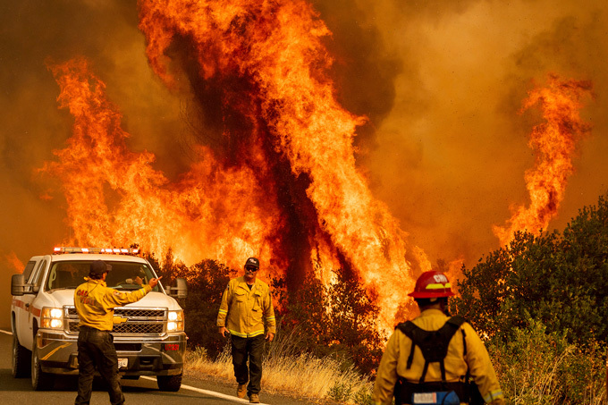
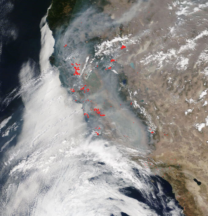
A “dry lightning” storm, which produced nearly 11,000 bursts of lightning between August 15 and August 19, set off devastating wildfires in across California. To date, these fires have burned more than 520,000 hectares.

That is “an unbelievable number to say out loud, even in the last few years,” says climate scientist Daniel Swain, of the Institute of the Environment and Sustainability at UCLA.

Lightning in Santa Cruz, California
Lightning crackles over Mitchell’s Cove in Santa Cruz, Calif., on August 16, part of a rare and severe storm system that triggered wildfires across the state.Shmuel Thaler/The Santa Cruz Sentinel via AP

The storm itself was the result of a particular, unusual set of circumstances. But the region was already primed for fires, the stage set by a prolonged and record-breaking heat wave in the western United States — including one of the hottest temperatures ever measured on Earth, at Death Valley, Calif. — as well as extreme dryness in the region (SN: 8/17/20). And those conditions bear the fingerprints of climate change, Swain says.

The extreme dryness is particularly key, he adds. “It’s not just incremental; it absolutely matters how dry it is. You don’t just flip a switch from dry enough to burn to not dry enough to burn. There’s a wide gradient up to dry enough to burn explosively.”

Both California’s average heat and dryness have become more severe due to climate change, dramatically increasing the likelihood of extreme wildfires. In an Aug. 20 study in Environmental Research Letters, Swain and colleagues noted that over the last 40 years, average autumn temperatures increased across the state by about 1 degree Celsius, and statewide precipitation dropped by about 30 percent. That, in turn, has more than doubled the number of autumn days with extreme fire weather conditions since the early 1980s, they found.

LNU Lightning Complex wildfire
An unusual dry lightning storm combined with very dry vegetation and a record-breaking heat wave to spark hundreds of wildfires across California between August 15 and August 19. One group of these fires, collectively referred to as the LNU Lightning Complex, blazed through Napa, Sonoma, Solano, Yolo and Lake counties. Firefighters continued to battle the LNU complex fires on August 23, including in unincorporated Lake County, Calif. (shown).AP Photo/Noah Berger

Although fall fires in California tend to be more wind-driven, and summertime fires more heat-driven, studies show that the fingerprint of climate change is present in both, Swain says. “A lot of it is very consistent with the long-term picture that scientists were suggesting would evolve.”

Though the stage had been set by the climate, the particular trigger for the latest fires was a “dry lightning” storm that resulted from a strange confluence of two key conditions, each in itself rare for the region and time of year. “’Freak storm’ would not be too far off,” Swain says.

California wildfire smoke
Smoke still engulfed California on August 24, as more than 650 wildfires continued to blaze across the state (red dots indicate likely fire areas). The two largest fires, both in Northern California, were named for the lightning storm that sparked them: the LNU Lightning Complex and the SCU Lightning Complex. They are now second and third on the list of California’s largest wildfires.NASA Worldview, Earth Observing System Data and Information System (EOSDIS)

The first was a plume of moisture from Tropical Storm Fausto, far to the south, which managed to travel north to California on the wind and provide just enough moisture to form clouds. The second was a small atmospheric ripple, the remnants of an old thunderstorm complex in the Sonoran Desert. That ripple, Swain says, was just enough to kick-start mixing in the atmosphere; such vertical motion is the key to thunderstorms. The resulting clouds were stormy but very high, their bases at least 3,000 meters aboveground. They produced plenty of lightning, but most rain would have evaporated during the long dry journey down.

Possible links between climate change and the conditions that led to such a dry lightning storm would be “very hard to disentangle,” Swain says. “The conditions are rare to begin with, and not well modeled from a weather perspective.”

But, he adds, “we know there’s a climate signal in the background conditions that allowed that rare event to have the outcome it did.”

Midwest derecho

On August 10, a powerful windstorm with the ferocity of a hurricane traveled over 1,200 kilometers in just 14 hours, leaving a path of destruction from eastern South Dakota to western Ohio.

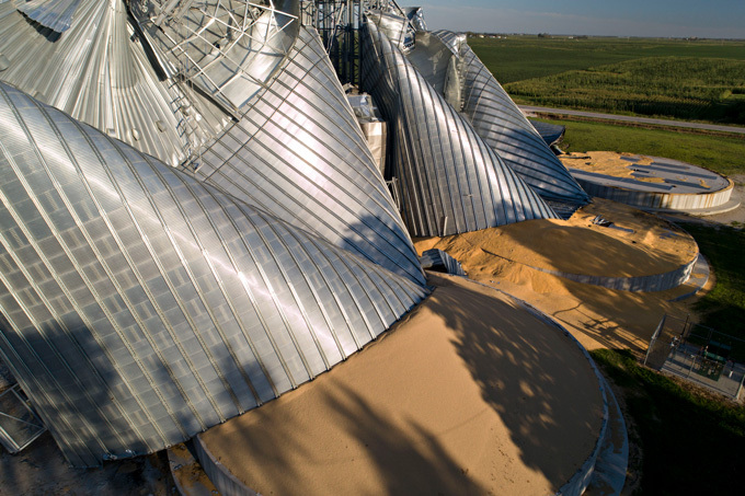
The storm was what’s known as a derecho, roughly translating to “straight ahead.” These storms have winds rivaling the strength of a hurricane or tornado, but push forward in one direction instead of rotating. By definition, a derecho produces sustained winds of at least 93 kilometers per hour (similar to the fury of tropical storm-force winds), nearly continuously, for at least 400 kilometers. Their power is equally devastating: The August derecho flattened millions of hectares of crops, uprooted trees, damaged homes, flipped trucks and left hundreds of thousands of people without power.

Iowa derecho storm damage
A powerful derecho on August 10 twisted these corn and soybean grain bins in Luther, Iowa. The storm-force winds swept 1,200 kilometers across the U.S. Midwest, from South Dakota to Ohio, damaging homes and croplands and leaving hundreds of thousands of people without power.Daniel Acker/Getty Images

The Midwest has had many derechos before, says Alan Czarnetzki, a meteorologist at the University of Northern Iowa in Cedar Falls. What made this one significant and unusual was its intensity and scale — and, Czarnetzki notes, the fact that it took even researchers by surprise.

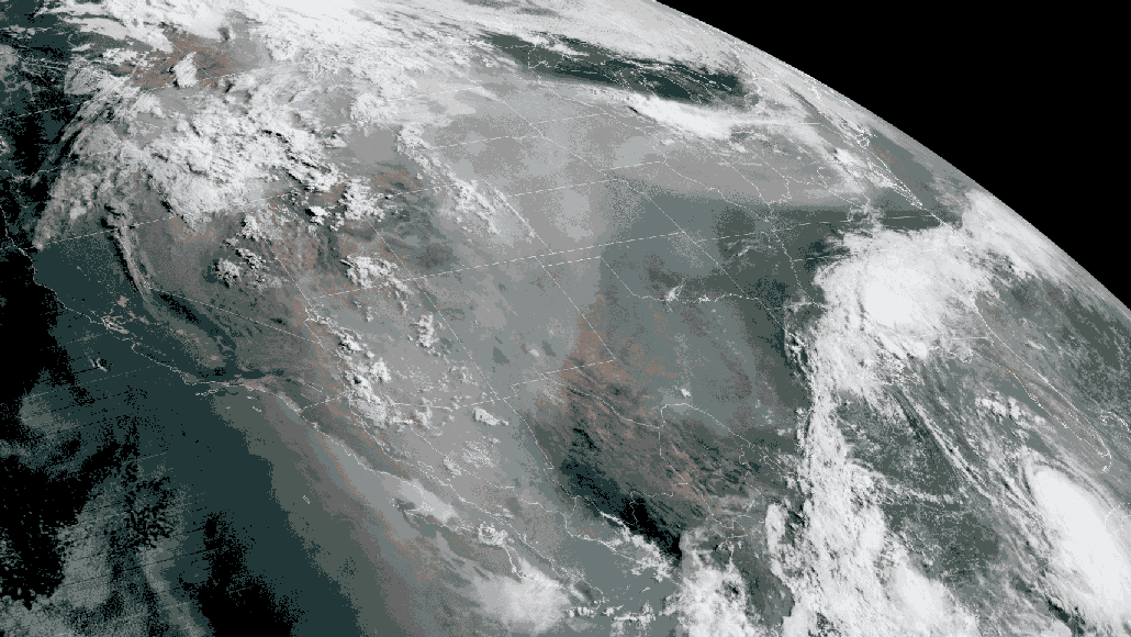
Derechos originate within a mesoscale convective system — a vast, organized system of thunderclouds that are the basic building block for many different kinds of storms, including hurricanes and tornadoes. Unlike the better-known rotating supercells, however, derechos form from long bands of swiftly moving thunderstorms, sometimes called squall lines. In hindsight, derechos are easy to recognize. In addition to the length and strength conditions, derechos acquire a distinctive bowlike shape on radar images; this one appeared as though the storm was aiming its arrow eastward.

But the storms are much more difficult to forecast, because the conditions that can lead them to form can be very subtle. And there’s overall less research on these storms than on their more dramatic cousins, tornadoes. “We have to rely on situational awareness,” Czarnetzki says. “Like people, sometimes you can have an exceptional storm arise from very humble origins.”
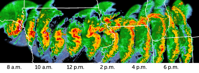
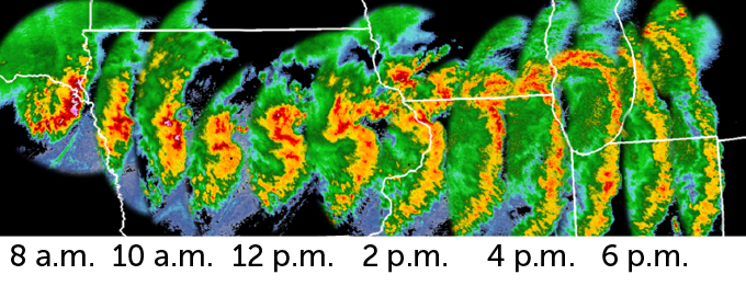
The Aug. 10 derecho was particularly long and strong, with sustained winds in some places of up to 160 kilometers per hour (100 miles an hour). Still, such a strong derecho is not unheard of, Czarnetzki says. “It’s probably every 10 years you’d see something this strong.”

Whether such strong derechos might become more, or less, common due to climate change is difficult to say, however. Some anticipated effects of climate change, such as warming at the planet’s surface, could increase the likelihood of more and stronger derechos by increasing atmospheric instability. But warming higher in the atmosphere, also a possible result of climate change, could similarly increase atmospheric stability, Czarnetzki says. “It’s a straightforward question with an uncertain answer.”

Atlantic hurricanes

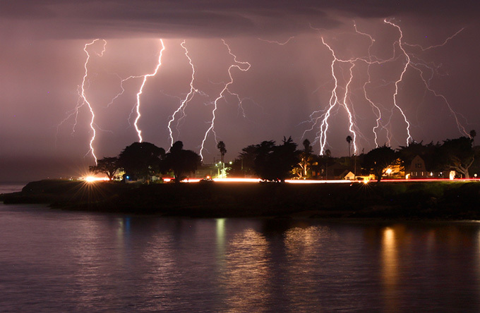
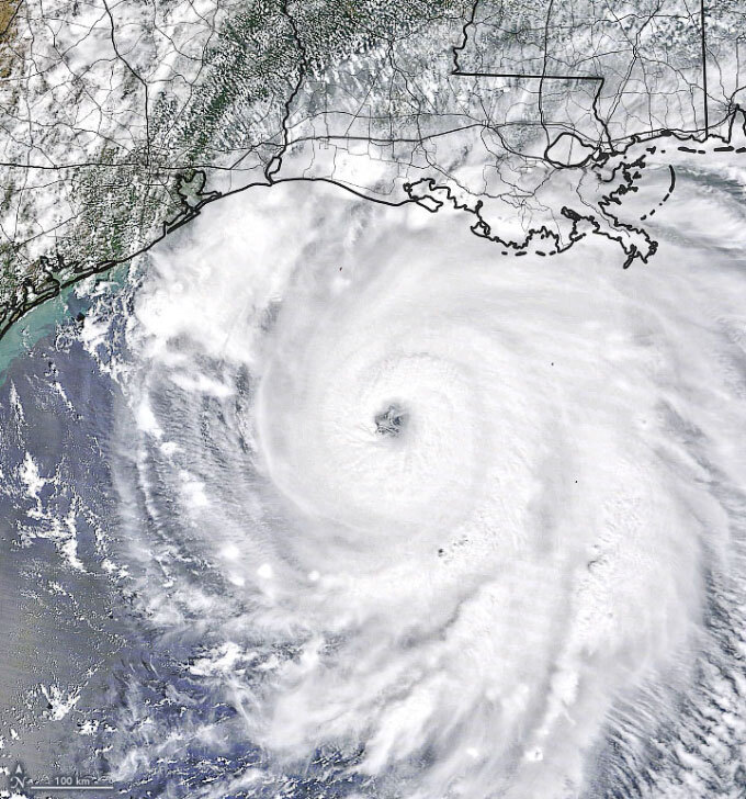
Hurricane Laura roared ashore in Louisiana in the early morning hours of August 27 as a Category 4 hurricane, with sustained winds of about 240 kilometers per hour (150 miles per hour). Just two days earlier, the storm had been a Category 1. But in the mere 24 hours from August 25 to August 26, the storm rapidly intensified, supercharged by warm waters in the Gulf of Mexico.

Hurricane Lauran satellite image
Hurricane Laura intensified rapidly due to the warm waters of the Gulf of Mexico, strengthening from a Category 1 hurricane on August 25 to a Category 4 on August 26 (shown). The U.S. National Hurricane Center warned coastal residents of Louisiana and Texas to expect a storm surge — ocean waters elevated by the storm above the normal tide level — of as much as five meters.NOAA

The Atlantic hurricane season is already setting several new records, with the National Oceanographic and Atmospheric Administration predicting as many as 25 named storms, the most the agency has ever anticipated (SN: 8/7/20).

At present, 2005 still holds the record for the most named storms to actually form in the Atlantic in a given season, at 28 (SN: 8/22/18). But 2020 may yet surpass that record. By August 26, 13 named storms had already formed in the Atlantic, the most ever before September.

The previous week, researchers pondered whether another highly unusual set of circumstances might be in the offing. As Laura’s track shifted southward, away from Florida, tropical storm Marco appeared to be on track to enter the Gulf of Mexico right behind it. That might have induced a type of physical interaction known as a Fujiwhara effect, in which a strong storm might strengthen further as it absorbs the energy of a lesser storm. In perhaps a stroke of good luck in the midst of this string of weather extremes, Marco dissipated instead.

As Hurricane Laura approached landfall, the U.S. National Hurricane Center warned that “unsurvivable” storm surges of up to five meters could inundate the Gulf Coast in parts of Texas and Louisiana. Storm surge is the height to which the seawater level rises as a result of a storm, on top of the normal tidal level.

hurricane debris in Lake Charles, Louisiana
Debris litters Lake Charles, La., in the aftermath of Hurricane Laura’s landfall August 27.AP Photo/Gerald Herbert

It’s impossible to attribute the fury of any one storm to climate change, but scientists have observed a statistically significant link between warmer waters and hurricane intensity. Warm waters in the Atlantic Ocean, the result of climate change, juiced up 2017’s hurricanes, including Irma and Maria, researchers have found (SN: 9/28/18).

And the Gulf of Mexico’s bathlike waters have notably supercharged several hurricanes in recent years. In 2018, for example, Hurricane Michael intensified rapidly before slamming into the Florida panhandle (SN: 10/10/18). And in 2005, hurricanes Katrina and Rita did the same before making landfall (SN: 9/13/05).

As for Laura, one contributing factor to its rapid intensification was a drop in wind shear as it spun through the Gulf.  Wind shear, a change in the speed and/or direction of winds with height, can disrupt a storm’s structure, robbing it of some of its power.  But the Gulf’s warmer-than-average waters, which in some locations approached 32.2° C (90° Fahrenheit), were also key to the storm’s sudden strength. And, by warming the oceans, climate change is also setting the stage for supercharged storms, scientists say. 

Algorithm aims to alert consumers before they use illicit online pharmacies

Original post: Newswise - Drug and Drug Abuse Algorithm aims to alert consumers before they use illicit online pharmacies

Newswise imageIn a study, a team of Penn State researchers report that an algorithm they developed may be able to spot illicit online pharmacies that could be providing customers with substandard medications without their knowledge, among other potential problems.

Clubs Closed? Study Finds Partygoers Turn to Virtual Raves and Happy Hours During Pandemic

Original post: Newswise - Drug and Drug Abuse Clubs Closed? Study Finds Partygoers Turn to Virtual Raves and Happy Hours During Pandemic

People have traded in nightclubs and dance festivals for virtual raves and Zoom happy hours as a result of lockdowns during the COVID-19 pandemic–yet, many are using drugs in these socially distanced settings, according to a new study by researchers at NYU Grossman School of Medicine and the Center for Drug Use and HIV/HCV Research at NYU School of Global Public Health.

COVID poses hardships for people with substance abuse problems

Original post: Newswise - Drug and Drug Abuse COVID poses hardships for people with substance abuse problems

FACULTY Q&ABoth fatal and nonfatal overdoses have increased this year compared to last, according to a recent report by the Overdose Data Mapping Application Program. And, anecdotal information suggests that compared to last year, people in recovery are relapsing at alarming rates.Faculty from the University of Michigan School of Nursing’s Center for the Study of Drugs, Alcohol, Smoking and Health discuss why the pandemic has hit people with substance abuse problems especially hard and the expanded role of virtual recovery programs.

Clinical Utility of Hana(r) Orthopedic Table Highlighted in New Study: 97% of Direct Anterior Approach Hip Replacement Patients Needed Little to No Opioid Pain Medication After Surgery

Mizuho OSI(r), a leading manufacturer of specialty surgical tables and pressure injury abatement solutions would like to announce the publication of a new clinical study titled “23-hour Total Hip Replacement Requiring Only 3.5 Opioid Pills Through 6 Weeks: A Non-selected Prospective Consecutive One Year Cohort”, by Andrew Wickline MD, now appearing in the peer-reviewed Journal of Orthopedic Experience & Innovation (JournalOEI)

Readers ask about Mars dust storms, Fermi bubbles and more

cover of July 4, 2020 & July 18, 2020 issue

Mars dust up

Predicting dust storms on Mars will help keep rovers and future astronauts safe on the planet’s surface, Lisa Grossman reported in “How upcoming missions to Mars will help predict its wild dust storms” (SN: 7/4/20 & 7/18/20, p. 24).

The story reported that scientists struggle to understand how dust gets lifted into the air. “Have they considered static electricity? A static charge on the dust particles would create repulsion between separate particles and between particles and the ground, levitating them enough to be moved by the winds,” reader Bruce M­erchant wrote.

Yes, electric fields formed by colliding dust grains can help increase the amount of dust in the atmosphere. Though electric forces alone are not enough to explain dust lift on Mars, the forces “are critical in the dust-­lifting process and should be taken into account,” says Germán Martínez of the Lunar and Planetary Institute in Houston. Electric forces also loft dust into Earth’s atmosphere, Grossman notes. Studies in the Moroccan desert have suggested that electric fields can increase the amount of dust injected into the atmosphere by a factor of 10.

Merchant thought static electricity could have contributed to the demise of NASA’s P­hoenix Mars Lander and Mars Exploration Rover Opportunity. “Do any current or planned missions to Mars include sensors that could detect and measure static electrical activity?” he asked.

Electric fields associated with dust lifting could affect the performance and lifetime of hardware on Mars, Grossman says, “although I don’t think it was the critical factor for P­hoenix or Opportunity.” No past mission has measured electric fields, nor will any of the three missions launched in 2020. The European Space Agency’s Schiaparelli lander was supposed to take such measurements, but the lander crashed into the Red Planet in 2016. The ExoMars mission lander slated to launch in 2022 will measure electric fields. “That’ll be a precious piece of information,” Martínez says.

Red Planet preppers

Future Mars explorers will need protections from microgravity and radiation, Maria Temming reported in “What will astronauts need to survive the dangerous journey to Mars?” (SN: 7/4/20 & 7/18/20 p. 18).

Reader Henry Jones wondered if a protective magnetic field could be created to surround a Mars-bound spaceship.

NASA is investigating whether it’s possible to build a device that would generate a magnetic field to repel radiation, as Earth’s magnetic field does. The idea “is in its infancy,” says J­ennifer Fogarty, chief scientist of NASA’s Human Research Program at Johnson Space Center in Houston. “We’re all rooting for it.… It would be amazing for something like that to arrive. I can’t depend on it, though.”

Gassy with a chance of bubbles

Scientists spotted visible light emanating from gas blobs, called Fermi bubbles, that sandwich the plane of the Milky Way g­alaxy, Emily Conover reported in “The Milky Way’s giant gas bubbles were seen in visible light for the first time” (SN: 7/4/20 & 7/18/20, p. 5).

“Has there been a survey of Fermi bubbles around other galaxies?” reader Eric Anderson asked.

Yes, researchers have looked for Fermi bubbles around nearby galaxies, Conover says, but the bubbles are not easy to spot. “There is some evidence for bubbles around the neighboring Andromeda galaxy, about 2.5 million light-years away,” she says.

What’s in a name?

Astronomers identified two unusual bursts of light, one known as CSS161010 and the other nicknamed the Koala, Emily Conover reported in “A weird cosmic flare called the ‘Cow’ now has company” (SN: 7/4/20 & 7/18/20, p. 12).

“A ‘cute’ nickname for CSS161010 would be Tenten, for the obvious reason, but also because (thanks to a Google search) it is the name of a female character in [the] Japanese manga series … Naruto,” reader Oliver Del Signore wrote. “If Tenten or some other nickname is eventually assigned, I hope Science News will include a short update in a future issue.”

IUPUI study looks at prevention strategy for substance use disorder

Original post: Newswise - Drug and Drug Abuse IUPUI study looks at prevention strategy for substance use disorder

A recent study from IUPUI found risk factors for substance use disorder affect age groups differently and proposes a primary prevention strategy for substance use disorder that is individualized for people within defined age groups.

How two new fungus species got named after the COVID-19 pandemic

Never mind that they’re not viruses. Catching the trend of cocktails called quarantinis and registered racehorse names like Wearamask, two fungal species now have pandemic-inspired monikers. In a nod to the new normal of science, both names grew out of the frustrations of trying to keep research alive in an upside-down world (SN: 5/23/01).

In the first case, tiny, fungal leopard spots on saw palmetto leaves turned out to be new to science. Despite looks, they belong to the same family (Xylariaceae) as the black stubs that rise from the ground called dead man’s fingers.

The leopard spots are not just a new species but represent a whole new genus, mycologist Pedro Crous and colleagues announced in the July 2020 Persoonia. As the pandemic raced across Europe, Crous — working mostly from home instead of in his lab at Westerdijk Fungal Biodiversity Institute in Utrecht, the Netherlands — named the genus “Diabolocovidia,“ or “devilish COVID.”

Finding the new species wasn’t that hard, says forest pathologist Jason Smith. He’d had some spotty leaves lying around his lab at the University of Florida in Gainesville when another coauthor visited in search of novelties. “This speaks to something a little broader,” Smith says. Even everyday places hold new fungal species because, unlike birds and mammals, most fungi are unnamed.

In the second case, Purdue University biologist Danny Haelewaters was supposed to be on six-nation field trip from Panama to eastern Russia.  Instead, he was grounded in West Lafayette, Ind., socially distant from his coauthor André De Kesel, a mycologist at Belgium’s Miese Botanic Garden.

Many unknowns don’t get the love they deserve because they’re parasites, Haelewaters laments. Yet “parasites are so incredibly diverse” and influence a host species so much they can essentially “run ecosystems,” he says.

Laboulbenia quarantenae fungi
Another new fungus species with a pandemic-themed name, Laboulbenia quarantenae, is known only as microscopic sexually reproducing hairlike tufts on one species of ground beetle. Unlike most fungi, this one doesn’t form the classic cobwebby filaments of mycelium.André De Kesel

In hopes of raising interest in these overlooked wonders, he chose the epithet quarantenae for a new species of microscopic Laboulbenia fungus described July 30 in MycoKeys. Found twice so far in the botanic garden on a kind of ground beetle, the L. quarantenae fungi look like tiny, warped bananas with antlers. The new species reproduces only via sex, which is weirdly simple for a fungal lifestyle.