This post was originally published on this site
At Antelope Island State Park near Salt Lake City in the fall of 2022, three duck hunters dragged a sled across cracked desert sand in search of the water’s edge. The birds they sought were bunched in meager puddles far in the distance. Just to the west, the docks of an abandoned marina caved into the dust and a lone sailboat sat beached amid sagebrush.
“Biologists are worried that we’re on the brink of ecological collapse of the lake,” says Chad Yamane, the regional director of Ducks Unlimited, a nonprofit that conserves, restores and manages habitats for North America’s waterfowl, and a waterfowl hunter himself.
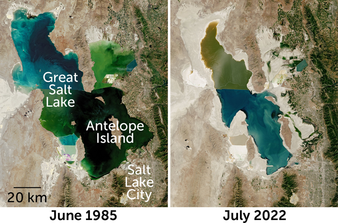
Last fall, the Great Salt Lake hit its lowest level since record keeping began. The lake’s elevation sank to nearly six meters below the long-term average, shriveling the Western Hemisphere’s largest saline lake to half its historic surface area. The lake’s shrinking threatens to upend the ecosystem, disrupting the migration and survival of 10 million birds, including ducks and geese.
Duck hunters aren’t the only ones worried about the Great Salt Lake. The decades-long decline in lake level is raising alarm bells for millions of people who live in the region. As the lake recedes, its namesake city and surrounding communities face a host of potential problems. The low lake level and increasing salinity threaten to disrupt economic mainstays like agriculture, tourism, mineral extraction and brine shrimp harvesting. Exposed sediments can also reduce air quality and so threaten public health. “It concerns everyone,” Yamane says. “It’s now on the forefront of every Utahan’s mind.”
And the Great Salt Lake isn’t unique. Many of the world’s saline lakes are facing a double whammy: People are taking more water from the tributaries that feed the lakes, while a hotter, drier climate means it takes longer to refill them.
Found on every continent, saline lakes include the Caspian Sea, the largest lake in the world, as well as the lowest, the Dead Sea. Saline lakes are terminal lakes — they have no drain, meaning no rivers flow out of them. As water evaporates, salts are left behind from the minerals that wash off the surrounding landscape. Since they are usually found in arid landscapes that receive little precipitation, saline lakes are the first in line to be affected by long-term droughts, which are becoming more common with climate change.
At the same time, the people who live in these deserts divert freshwater for crops, homes and industry. Residents siphon water from streams and rivers into canals, pipelines or reservoirs before it reaches the lakes. And as the lakes shrink, their concentration of salt increases.
Lake Poopó, a high-elevation lake in Bolivia that used to stretch 90 kilometers long and 32 kilometers wide, is now a salty mud flat. The Aral Sea in Kazakhstan and Uzbekistan, once the world’s fourth largest lake, has at times in recent decades withered to a tenth of its historic 68,000-square-kilometer surface area. India’s largest inland salt lake, Sambhar Salt Lake, is in severe decline, as is Africa’s Lake Chad. Some saline lakes, like Nevada’s Winnemucca Lake, dried up so long ago — the waters that fed it diverted to agricultural fields — that most people have forgotten they were ever wet.
According to a report released by researchers at Brigham Young University in January, the Great Salt Lake will likely also disappear within five years if residents continue their current rate of “unsustainable” water consumption.
The good news is Utahans still have time to halt or even reverse the Great Salt Lake’s decline by using less water. Cutting agricultural and other outdoor water use by a third to half through a combination of voluntary conservation measures and policy changes would allow the lake to refill enough to support the region’s economy, ecology and quality of life, the report says. If Utahans succeed, the Great Salt Lake can be a model for how to save other saline lakes around the world.
Why is the Great Salt Lake declining?
Like other terminal lakes, the Great Salt Lake naturally rises or falls based on how much water falls into and evaporates out of its watershed each year. Most of the precipitation falls as snow in the winter, melting each spring to fill streams that eventually empty into the lake. Because it’s surprisingly shallow for its size — an average of just over four meters deep — the Great Salt Lake fills or drains quickly. In the 1980s, for instance, a wet spell swelled the lake’s surface area to nearly 6,000 square kilometers, more than twice as big as it is today.
Despite natural variations, the lake level is undisputedly trending downward. Hydrologic modeling by Wayne Wurtsbaugh and Sarah Null, both experts on the lake based at Utah State University in Logan, shows that if people had not started siphoning water from the rivers and streams in the region in 1847, when Mormon settlers led by Brigham Young arrived, the lake would be 3.4 meters higher than it is currently.
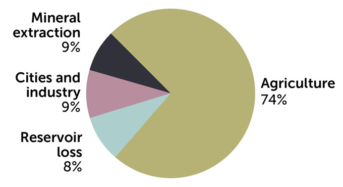
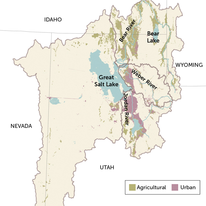
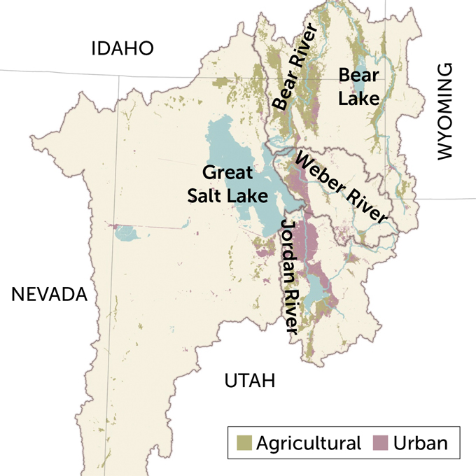
Today, three-quarters of the water consumed within the Great Salt Lake watershed is used to irrigate crops, mainly hay that feeds cattle that produce beef or dairy, the state’s chief agricultural commodities.
Mineral extraction from the Great Salt Lake accounts for 9 percent of the water consumed. Companies divert briny water directly from the lake to extract its minerals and produce table salt, fertilizer or magnesium metal. Another 9 percent of the water consumed in the basin gets piped to cities to supply homes and businesses with water for indoor, outdoor and industrial uses. The remaining 8 percent is lost from evaporation from lakes and reservoirs in the basin.
Climate change has also contributed to the Great Salt Lake’s record lows. The worst megadrought in 1,200 years has ensnared the American Southwest for the last 22 years. The lake isn’t refilling fast enough to keep up with the withdrawals upstream, while higher temperatures spur more evaporation from the lake.
People use more water to grow crops or keep lawns green when it’s hot and dry, which Patrick Donnelly, a research scientist with the U.S. Fish and Wildlife Service in Missoula, Mont., likens to a climate tax on our waterways. An agricultural producer needs 20 percent more water to grow the same crops in northern Utah than he did 15 years ago, Donnelly says.
Donnelly and colleagues measured changes in 18 saline lakes in the Intermountain West, including the Great Salt Lake, finding an average surface area decrease of 27 percent from 1984 to 2018. The surface area of wetlands in the region diminished by nearly half. The researchers reported in 2020 in Global Change Biology that these losses were driven largely by demands from irrigated agriculture coupled with higher temperatures that increase evaporation.
And the demand for freshwater in is only increasing. Utah is the fastest growing state in the United States, and 80 percent of the people live in the Great Salt Lake watershed.
Donnelly says it’s “unrealistic” to think that the Great Salt Lake region can stretch its water far enough to meet current and increasing demands. He points to a proposal to further dam and divert the Bear River — the tributary that provides over half of the Great Salt Lake’s freshwater and is already riddled with canals, ditches and reservoirs — to supply growing communities in Utah. The project would lower the level of the Great Salt Lake by more than a meter and a half and push salinity to over 22 percent, damaging the lake’s invertebrate community, Wurtsbaugh and Null reported in the book Great Salt Lake Biology, published in 2020.
The consequences of a dry Great Salt Lake
The region is already feeling the consequences of a shrinking lake. Mineral extraction industries are finding it increasingly difficult to get water to their ponds and processing plants. Some ranchers worry they won’t be able to take their full allotment of irrigation water from the lake’s freshwater tributaries. Even Utah’s famous ski resorts feel the impact: An estimated 5 to 10 percent of the fluffy powder that draws millions of tourists to the area’s slopes comes from snowfall triggered by the lake’s relatively warm waters.
If the Great Salt Lake dries completely, the consequences become much more dire. Owens Lake in Central California offers an example of what happens when saline lakes are drained for human water consumption. It went dry in 1926, just 13 years after the Los Angeles Department of Water and Power diverted the Owens River into a 375-kilometer-long aqueduct to supply water to Southern California. This engineering feat turned fertile farmlands into an eerie dust bowl and caused health problems for residents in nearby communities.
Once a lake bed is exposed, winds kick up ferocious dust storms. Those windblown sediments contribute to air pollution and can contribute to asthma, lung cancer and cardiopulmonary disease, among other health issues. Owens Lake has been among the largest sources of dust pollution in the nation. The City of Los Angeles has spent more than $2.5 billion mitigating the dust through projects at the lake bed such as shallow flooding, seeding and planting vegetation, spreading gravel or tilling the ground.
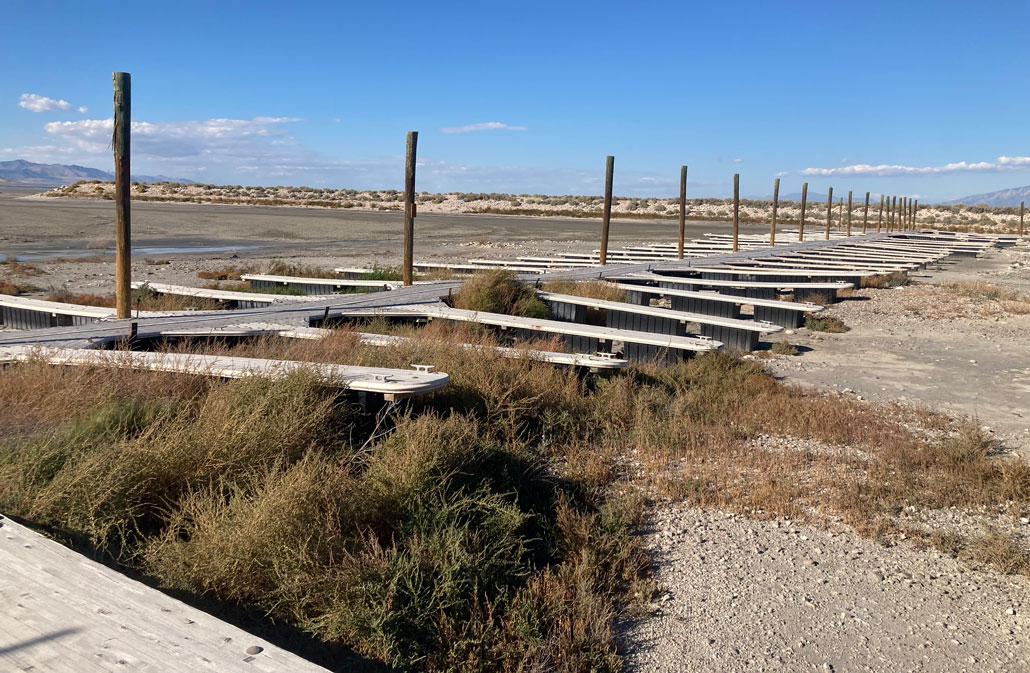
This is sobering news for Salt Lake City, which had at least seven times as much lake bed exposed last fall as Owens Lake. “In the summers when we get a strong south wind, you can literally watch a cloud of dust coming off the lake where the lake bed has been exposed because of the low receding water,” Yamane says.
Sediments at the bottom of saline lakes also collect a slew of pollutants from human activities, such as chemicals from urban and agricultural runoff and toxic mine waste. Historical mining and smelting around the Great Salt Lake, for example, deposited heavy metals like mercury and lead that have accumulated in the lake bed’s sediments. Once exposed, these metals can be transported by dust particles and may increase rates of disease associated with air pollution, according to the January report from the BYU team.
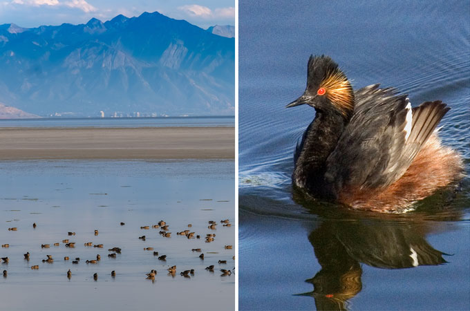
The drying is also bad for birds. The Great Salt Lake supports nearly 350 different species, many of them migratory birds that use the lake to rest and refuel as they cruise north or south along the Central and Pacific flyways. While many migrating birds can make do with any lake, fresh or salty, some species are saline specialists, like eared grebes and phalaropes.
According to a 2017 report by the National Audubon Society, more than half of the saline lakes in the West that are most important for birds have shrunk by 50 to 95 percent in their surface area over the last 150 years. “The birds are competing now for a much more limited resource than they did before,” says John Luft, manager of the Great Salt Lake Ecosystem Program at the Utah Division of Wildlife Resources.
During some fall migrations, 5 million eared grebes — perhaps 95 percent of the species’ entire population — have stopped over in Utah, Luft says. Each grebe needs to eat up to 30,000 brine shrimp per day from the Great Salt Lake before continuing on its long migratory journey. Brine shrimp flourish between 12 and 17 percent salinity, but they start to decline drastically once salinity passes that threshold — and the south arm of the Great Salt Lake reached 18 percent last September. (For comparison, the ocean averages about 3.5 percent salinity.)
What to do about Great Salt Lake’s drying?
While Wurtsbaugh says that “drying is definitely the projection and the worry,” he believes residents can help halt the decline by using less water.
Null agrees. “We can save Great Salt Lake, but it’s a long solution, not something that we’re going to fix overnight.” The most important way to make progress, she says, is for people to care enough to change their behavior.
Utahans have the second highest per capita use of water in the country. Encouraging people to use less water is the simplest — and cheapest — way to begin refilling the Great Salt Lake. This includes using rain barrels, permeable pavement or xeriscaping in urban or suburban areas, as well as improving the efficiency of irrigation structures on farms and ranches.
Permanently mandating water cutbacks would cost between $5 to $32 per person, according to Wurtsbaugh and Null’s research. The BYU team’s report, coauthored by 32 Great Salt Lake experts, emphasizes that conservation is not only the most cost-effective response, but also “the only way to provide adequate water in time to save Great Salt Lake.” Specifically, the report stresses the importance of reducing outdoor water use, especially on agricultural fields.
Last year, faced with withering streams and ominous lake levels, the Utah State Legislature passed a slew of bills focused on voluntary water conservation. “Honestly, I look at this as our time to shine,” says Joel Ferry, executive director of the Utah Department of Natural Resources. “The people of Utah … want to solve the problem.”
Some of the recent legislation calls for obvious fixes — like banning any requirements that residents water their lawns. Before this legislation, fines for not keeping your grass green were common around Salt Lake City. Other laws focus on making sure basic systems are in place to track water use, from the individual to the watershed level.
For instance, the legislature allocated $250 million to install tens of thousands of meters to track people’s outdoor water use. According to Wurtsbaugh, a previous effort to install meters in the Weber River, which flows into the Great Salt Lake, showed that “just knowing how much water you’re using compared to what your neighbor’s using” meant people used about 25 percent less water. Metering also opens the door to charging people accurately — or more — for the water they use. Currently, most residents pay a flat fee for all outdoor water, regardless of whether they are watering a few flowers or filling an entire swimming pool.
Since agriculture accounts for three-quarters of the water use in the Great Salt Lake region, Utah is also encouraging farmers and ranchers to conserve water. This shift has the advantage of making operations more drought resilient, says Ferry, who is also a fifth-generation rancher who irrigates with water from the Bear River. “Producers want to be part of the solution. They have to be.”
In 2022, the Utah Department of Agriculture and Food’s Water Optimization Program granted $70 million to help farmers and ranchers install drip or sprinkler systems that use less water. The Utah State Legislature also appropriated $40 million last year to preserve flows to the lake. Much of that is dedicated to setting up a water trust to lease water rights from farmers or ranchers willing to sell. Essentially, a water trust would pay irrigators to leave some or all of the water they are permitted to use in the stream or river instead of diverting it to water crops. These water leases could last a single summer or several years.
Water leasing is helping restore other ailing saline lakes. In Nevada, purchasing water rights from willing sellers has boosted the level of Walker Lake, about 150 kilometers southeast of Reno. But because water is so valuable in the arid West, it’s an expensive way to refill a lake. The Walker Basin Restoration Program has spent at least $92 million but has only acquired 53 percent of the water needed to support native fish and wildlife in the lake.
Big infrastructure and Mother Nature
If water conservation programs don’t work, Utahans might be faced with a more extreme solution to save the Great Salt Lake.
The alternative to conservation measures, says Null, is “hanging our hopes on big new infrastructure projects” that attempt to refill the lake by bringing water from other basins. One example is the Central Utah Project, which has been in the works for more than 80 years and is still incomplete. This project pipes up to 310 billion liters of water from the Colorado River Basin in eastern Utah, infamously over-tapped already, into a series of reservoirs and tunnels to supply water for irrigation, municipal and industrial uses in the Great Salt Lake’s watershed. According to the U.S. Bureau of Reclamation, the initial plans for the Central Utah Project put it “among the most complex” water resources development projects ever undertaken by the bureau, estimated to cost $3 billion once all phases are complete.
In the Aral Sea, dikes were built to preserve the remaining sliver of wet habitat, which meant permanently sacrificing the rest of the historical lake area. In California, Mono Lake was saved by a lawsuit based on the public trust doctrine, which says that the government has a responsibility to protect the resources that belong to everyone. The court’s decision cut off water to cities in Southern California that held water rights to the river that fed Mono Lake. Los Angeles made up the difference in part through water conservation measures.
Ferry says Utah isn’t closing the door on any options. Some of the more unorthodox ideas floating around Salt Lake City include cloud seeding to boost precipitation and piping water from the Pacific Ocean to refill the lake. But the most common strategy echoed by the Utahans interviewed for this story: Pray for snow.
“I’m very optimistic that we are at the lowest of lows,” Ferry said last fall, “as long as we get some snow.”
Utah received a record-setting amount of snow this winter, so the situation is looking up … at least for now. But it will take several years of above-average precipitation to reverse Utah’s lingering drought.
“Mother Nature has a huge role to play in this,” Yamane says. “And it’s going to take a mind-set change, a cultural change and policy changes. But along with Mother Nature, we should be able to save it.”
.image-mobile {
display: none;
}
@media (max-width: 400px) {
.image-mobile {
display: block;
}
.image-desktop {
display: none;
}
}

